Showing posts with label Birdwatching. Show all posts

Sunday, 11 December 2016

A Capital Idea – Part 2: Richmond to Hackney Wick

Day 1: Richmond to Harrow-on-the-Hill

16.25 miles

Back in the summer, we experienced a taster of the Capital Ring – the daytime activity we coordinated to go along with an evening performance of the ballet Swan Lake at the Royal Opera House, Covent Garden – with a view to continuing the project over the winter months in the same way we had with the London LOOP last year.

Now that the nights were drawing in, it was time to tackle the walk in earnest. Once again, we made our arrangements around another event – this time, a session at the ATP World Tennis Finals at the O2 – but also tacked on our one last holiday day of the year to give us a good two-and-a-half days of walking.

The Thames on a gloomy November morning

After another of the now-familiar early Saturday morning train and tube commutes, we arrived in Richmond around 9.30am and made our way to the riverside where we had left off before.

Looking back to Richmond Bridge

Setting off under leaden skies, a steady rain accompanied us as we crossed the sluggish-looking Thames by the footbridge at Richmond Lock. Flirting with the extremities of Isleworth, we followed the path across the frontage of the Town Wharf pub (a different hour of a nicer day and a drink would have been welcome) and left the riverside to enter the Capability-Brown-landscaped grounds of Syon Park. The interior of the house, which I don’t think you can go into, was remodelled by architect Robert Adam (he of Adam Fireplace fame).

Brentford Lock

Exiting the park, we crossed the road and joined the Grand Union Canal at Brentford Lock and followed this under the M4 motorway to Osterley Lock, where Section 7 of the Ring officially ends. Strange to think: you can walk all the way to Birmingham from here, if you’ve a mind to do so – 140-odd miles of canal towpath, a route perhaps best undertaken in chunks!

Houseboats on the Grand Union

Section 8 continued along the towpath, first crossing the River Brent, then veering right to follow it at Hanwell Bottom Lock near Ealing Hospital.

Passing beneath the Wharncliffe Viaduct

After passing beneath the impressive Wharncliffe Viaduct (built in 1838 by Isambard Kingdom Brunel to carry the Great Western Railway from London to Bristol) we entered Churchfield Recreation Ground and took advantage of the benches for an early lunch break. It was still raining, and although our sandwiches may have got a bit soggy round the edges, it didn’t matter – just being out on a decent walk, with nothing to worry about for a few hours, was much more of a tonic than a wet day in Hanwell might initially suggest.

Having passed through Brent Lodge Park, the Brent Valley Golf Course and Perivale Park, we crossed the A40 by footbridge and made our way towards Greenford and the end of section 8.

Crossing the A40 near Perivale

Checking the time, we could see it was still quite early – with a short rest break we could carry on. The Costa at Westway Cross Shopping Park provided the opportunity, and although we looked slightly at odds with the rest of the clientele with our rucksacks, boots and soaking waterproofs, we took the chance to rest-up, enjoy an energising coffee and get warm and dry. 

Our new target was Harrow-on-the-Hill, still a good 90 minutes’ walk away. For a stretch we re-joined the Grand Union Canal – at least the Paddington Branch of it – as we passed through the Paradise Fields Wetlands (bit of a moot distinction on a day like today – everywhere was wet land, and the paradisal nature of the area camouflaged by mizzle).

Climbing to the summit of Horsenden Hill was hardly an alpine outing, but it did represent the stiffest ascent of the day. It was also the only place where we became “navigationally challenged” all weekend, as the landmark on which the instructions were based was missing.

After a couple of minutes’ searching, we guessed the right path and descended into Sudbury, weaving through the streets and past football fields before a steep-ish climb brought us out on to the road into Harrow-on-the-Hill.

This alleyway is named after the character in Anthony
Trollope's Barchester Chronicles novels

The light was beginning to fade as we made our way through the village and left the Capital Ring for the day, and by the time we reached the station it was as good as dark. It had been a long day, but a good one – we’d covered more ground than we expected, and much of that through pleasant parks or on waterside walks.

Beginning to get dark in Harrow-on-the-Hill

Back in central London, we had beers and burgers at the Exmouth Arms – a pub situated a couple of streets away from Euston Station, and full of the after-work crowd in the week – then the recollection of an early start had us heading to our hotel for a good nights’ sleep.

Day 2: Harrow-on-the-Hill to Hendon

9.00 miles

Refreshed and raring to go, we were back in Harrow-on-the-Hill well before 9.00am, climbing back up to the village to re-join the Capital Ring. In contrast to yesterday, it was a bright, late-autumn morning of sunshine and blue skies.

On the way back up to Harrow-on-the-Hill

We made our way through the village and the grounds of Harrow School. This is where the great and the good are educated: Winston Churchill and Lord Byron, the author Anthony Trollope and playwright Richard Brinsley Sheridan are just a few of the successful who passed through these hallowed halls.

St Mary's Church

We picked our way between swathes of morning-coated soon-to-be peers and future PMs. It has to be said, though, that despite the beauty of the setting and the academic reputation of the place, the air felt no more rarefied than elsewhere and the skies seemed no more blue.

And the grass was definitely no greener. I may not mix in such circles, but I’m proud of my ordinary north Midlands roots and happy with my life, and, at the end of the day, I think that counts for a lot.

Playing fields, with Harrow School in the background

Crossing Watford Road by the only stile on the Capital Ring (according to the guide notes) we followed the Ducker Path beside Northwick Park Hospital and soon came to South Kenton station – the end of Section 9.

Section 10 began with a stretch through residential streets and parks. On this glorious autumn morning, Fryent Country Park was throng with joggers and dog-walkers. We gradually made our way to the top of Barn Hill, where we sat by a small pond for a coffee break. In relative terms, Barn Hill is a notable prominence, and there are good views to be had, for example to Wembley Stadium.

Pond at the top of Barn Hill

We descended through woods, then began the gentle climb up to Gotfords Hill and more long views. After another descent and more residential streets, we reached the Welsh Harp Reservoir, an attractive open water area with bird life, sailing and pleasant grounds through which to walk.

Welsh Harp Reservoir

As today’s walk was a shorter one for us, our end-of-day objective was fast approaching. Reached after crossing West Hendon Broadway and traversing further residential streets, we arrived at Hendon Station, the end of Section 10. We’d done well this morning, clocking up some 9 miles, although it was certainly made easier by such a beautiful morning – some reward for yesterdays’ soggy trudge.

Day 3: Hendon to Hackney Wick

15.00 miles

It was another overcast morning for our third day on the Ring, but we were out and about in good time despite our attending the ATP World Tennis finals at the O2 the evening before.

Avenue of trees, Hendon Park

We set out across Hendon Park, zig-zagged through a few residential streets, and entered Brent Park. To be honest, if you didn’t know, you wouldn’t guess that one of Britain’s busiest roads, the North Circular, ran only a few yards away, such is the secluded feel of the woodland.

Heron with Water Vole, Brent Park

The route runs beside the North Circular, beside the River Brent and then the Mutton Brook, for a mile or so, then bears right towards Hampstead Garden Suburb – created in the early 20th Century and designed to offer a range of housing set amongst open spaces, pedestrian walkways and mature trees.

Lyttleton Park

Residential streets, Lyttleton Playing Fields, more streets of attractive suburban houses passed. We reached East Finchley Tube and crossed the Great North Road into Cherry Tree Wood where we stopped for coffee and jaffa cakes and a chat with the locals.

Squirrel in Cherry Tree Wood

Moving on, we followed an undulating path through Highgate Wood and Queen’s Wood (remnants of the ancient Middlesex Forest) to reach Priory Gardens and the end of Section 11.

Entrance to Highgate Wood

A short, steep path through Highgate Spinney began Section 12. Then, after a short stretch of main road, we reached the Parkland Walk – London’s longest nature reserve – the bed of an old railway line converted into a recreational space after the tracks were lifted in 1970.

Parkland Walk

Navigation was easy for the next couple of miles, the only challenge being to avoid the herds of joggers and cyclists – it’s mid-Monday morning, don’t these people have jobs to go to?

Last time I was in Finsbury Park, Paul Weller was playing songs from the Stanley Road album to thousands of fans on a baking-hot afternoon in June 1996. It’s fair to say that there weren’t so many folks about on a wet Monday in November some twenty years later, but there was a café, and after an early breakfast and a good walk we were ready for food.

To be honest, the Finsbury Park café is not quite what you’d expect. It’s a lot more “locally-sourced-this” and “Fairtrade-that” than your average park caff. Of course, there’s nothing wrong with that – you don’t usually get grilled tomatoes on the vine with your fry up or sliced avocado in your Cajun Chicken Burger!

Monday lunchtime saw it well-populated by yummy Mummies and au pairs with children in tow, and I learnt more about breast-feeding in public in the half-hour we were there than I might ordinarily have anticipated.  

Next, we picked up the New River Path. New River is something of a misnomer – as a four-hundred-year-old artificial watercourse, it is neither “new” nor a “river” – but it was a pleasant walk that brought us out beside two artificial lakes, East Reservoir and West Reservoir, now given over to water sports and nature, and overlooked by some nice-looking new flats.

After a short stretch of road walking along Green Lane, we crossed Clissold Park and exited into Stoke Newington beside St Mary’s Church and the old Town Hall.

Not much call for fountain pen repairs these days ...

When we passed through Highgate, I had wondered whether the route would take in Highgate Cemetery. It didn’t, but Abney Park Cemetery was an interesting alternative: a non-denominational space containing graves of all religions, there are many notable people buried here including William Booth, founder of the Salvation Army.  

Grave of William Booth, founder of the Salvation Army

Leaving the cemetery, we crossed Stamford Hill and began Section 13 of the Ring. For the first mile-or-so, the route took us through the residential streets of one of London’s larger Jewish communities, before bearing off into Springfield Park from where there were great views over to the Walthamstow Marshes. A handy bench provided the chance for a break – just the tonic needed before tackling the final few miles.

The Lea Valley provided the conduit for those last miles. We crossed the river by the Springfield Marina, and picked up the riverside path heading south-east. There was a little mizzle in the air, but the going was easy as we passed pubs and narrowboats and bridges and weirs along the way.

Springfield Marina

Towards the end of the section, the Olympic Park came into view, along with some of the housing and other facilities built for the 2012 games. We won’t pass the stadium until next time, but there has been a fair bit of regeneration of what must have been quite a run-down area.

That regeneration hasn’t stretched to everywhere in the vicinity, though, as the walk along White Post Lane to Hackney Wick station proved.

Back in central London, we popped across to Oxford Street for a spot of Christmas shopping. Talk about a change of scenery! There was a good display of lights, but too many people for my liking. Mission accomplished, we retired to the Exmouth Arms again for a couple of well-earned pints before catching the train home.

It’d been a good weekend – and good use of our last holiday day of the year, too. We’d completed a good chunk of the Capital Ring, which had continued to surprise and delight at regular intervals. Come the New Year, we will be back for more.

Sunday, 11 September 2016

A Dash To Dentdale

We have always enjoyed our trips to Dentdale, a beautiful part of the country we have been visiting regularly for over 25 years.

In recent years, our visits have become rather fewer and further between, but the August Bank Holiday weekend provided the perfect opportunity for a brief re-acquaintance and, although more succinct than we would have liked, it was just the tonic we needed after a busy few weeks.

We did a bit of pottering about on Saturday afternoon after the drive up in the morning, but during the next two days we managed a couple of decent outings. On Sunday, we walked from our digs along the Dales Way to Sedbergh and back. 

Rosehips ripening


The rivers were full after heavy overnight rain


Cloud just lifting from the top of Middleton Fell

Although August by date, there was clear evidence that Autumn was fast approaching. Rivers were swollen from recent rains, blackberries were already ripe in the hedgerows, we picked wild raspberries as we went. 

Looking towards the Lune Valley


From the hillside on the way into Millthrop, we could see the restored
Pepperpot building in the grounds of Sedbergh School


Returning through Dent village


Nuthatch on the bird feeder

Monday dawned rather brighter, and we chose a walk that gained height above the dale, affording great views to almost all points of the compass.

Denthead viaduct on a brighter morning


Picking up the Pennine Bridleway


It's a National Trail!


Looking back towards Ingleborough and Pen-y-ghent


View from near the top of Arten Gill


Soaking up the far-reaching views on a perfect day for walking,
with the mountains of the Lake District in the far distance


Dentdale laid out below us in all its glory


Back in the dale, the rivers are quieter today


Sunlight catching the peat-stained waters of the River Dee

Saturday, 4 June 2016

London LOOP - Day 10

Enfield Lock Station to Noak Hill

18.25 miles

Since the flurry of activity earlier in the year, walking opportunities have been somewhat curtailed by a heavy workload and other commitments. But life can’t all be about business: getting back on the trail is a necessity we can’t ignore, and with a busy summer schedule looming and a new long-distance project on the horizon, the business in hand was that of completing the London LOOP.

Sadly, we weren’t able to devote the whole weekend to walking, so we will have to do the final miles another day. But we had enough time made a big day of it, ending weary and aching after the longest walk of the year so far – physically tired but mentally relaxed being the ideal antidote to overwork.

An early morning rail and tube journey deposited us at Enfield Lock Station just after 9.00am, where the first objective to overcome was to negotiate the railway line between busy crossing barriers.

Section 18 of the LOOP runs from Enfield Lock Station to Chingford, and despite an unprepossessing start this section – indeed the whole day – had plenty of rural charm to offer. So much so, in fact, that the route itself barely passed anything remotely capable of dispensing refreshments for hours at a time.

Enfield Lock on the River Lea Navigation

After re-joining the LOOP beside the Turkey Brook, we crossed the bridge over busy Mollison Avenue to arrive at Enfield Lock itself, lock number 13 on the River Lea Navigation located in the Lea Valley Regional Park near the site of the disused Royal Small Arms Factory where the famous Lee Enfield rifle (stalwart weapon of the Boer War, WWI and WWII) was once made.

May blossom, Sewardstone Marsh Nature Reserve

Leaving Enfield Lock, the route heads out into open countryside as it weaves its way through Sewardstone Marsh Nature Reserve and climbs into the hills beyond, from where there are extensive views to be had across two reservoirs to central London.

Epping Forest is London’s largest green space – an area of ancient woodland and formerly a Royal forest used for hunting. It provides recreational opportunities for many of the local residents – including, if history be true, the kind of recreation favoured by Dick Turpin and other notable Highwaymen.

I have to admit, though, that besides the above, I can’t recall ever having set foot in it before, and knew almost nothing about it other than that gleaned from the lyrics of the Genesis song The Battle of Epping Forest. In real life, it is actually rather lovely.

Passing through the grounds of Gilwell Park, home of the Scout Association HQ, we emerged on Yardley Hill, dropping down to climb again into Hawk Wood and walk through the trees beside Chingford Golf Course. After a short stop for drinks and snacks, a brief walk along a horse ride brought us out to Chingford Plain and the edge of the town at the end of Section 18.

Section 19 began with a short rise to Queen Elizabeth’s Hunting Lodge – apparently the only timber-framed hunting lodge left standing in England, and from where there were extensive views to be had over Epping Forest and Chigwell Plain – and a walk beneath ancient Oaks as we made our way towards Buckhurst Hill.

By now, the thin cloud cover of the early morning had burnt away; the sun broke through, and day was warming nicely. Sunscreen was applied – the first of the year.

At Buckhurst Hill, a cricket match was in the throes of getting underway. It was tempting to sit and watch, but we had other concerns: leaving the village, we headed out into the countryside once more, descending into Roding Valley on a green lane between trees. The rural idyll was somewhat shattered by the prison-camp architecture of the bridge over the Central line.

Looking out over Roding Valley from Buckhurst Hill

After negotiating a few residential streets, we re-entered green space (Roding Valley Meadows Nature Reserve) skirted a large lake (originally excavated to provide gravel for the nearby M11) spotted a Little Egret fishing in the shallows of the River Roding and followed the road over the M11 and into Chigwell. Like Chingford before, Chigwell is an area of well-to-do housing and leafy suburbs, with much more of a village-like feel than might be expected.

Despite one or two short stretches, this section had again delivered on use of the green spaces to pick a way through the fringes of London and the Essex borderlands: the number of different forests, nature reserves and country parks traversed during the day bearing testament to this.

We began our third section of the day climbing the hill of Chigwell High Road before striking out into countryside once more. The tone of the scenery had changed, though: whereas before we were passing though forests and country parks, we were now in agricultural land – at least for a while.

We crossed fields on a path that didn’t quite seem to tally with the map or the description, but which was obvious enough on the ground and well waymarked. In general, a combination of route descriptions, maps, on-the-ground signage and common sense make following the LOOP pretty straightforward. The trickiest bits are usually those through woods riddled with a multitude of minor paths – which one to choose?

After passing the water treatment works, we reached the road in Chigwell Row, skirted the recreation ground and crossed Romford Road to enter Hainault Forest Country Park. A mazy path through scrubby growth eventually brought us to the side of lake: on the far side was a golf course and, according to the signs, a café. 

We were ready for a break, but the thought of a diversion – even a relatively short one – didn’t appeal, so we continued along the edge of a wide, grassy meadow, watching three Green Woodpeckers at play in the grass, and found a handy bench from where there were views towards Canary Wharf and The City.  

By now it was mid-afternoon. Although there was time aplenty, we had to consider our return journey options, and catching the bus at Noak Hill looked to be favourite. All sections of the LOOP begin and end at a public transport connection, but it is noticeable there are fewer options in this northeast corner than at other points on the circuit.

Soon, we were crossing another golf course, taking a winding route through Mile Plantation before emerging to farmland once more. The approach to Havering Country Park, along a horse-trodden path where deep hoof-prints had solidified into an ankle-twisting unevenness, proved uncomfortable to walk on after fourteen-or-so miles. But the walk into Havering-atte-Bower, between the giant redwood trees of Wellingtonia Avenue, definitely made up for it.

Redwood trees, Wellingtonia Avenue

The Royal Oak pub marked the end of Section 20. A drink would have been nice, but with a couple of miles or so still to go, we didn’t feel there was time for a lengthy stop. Pressing on through more farmland, we passed the distinctive Round House Farm and small patches of woodland before crossing more fields on higher ground.

Beyond Paternoster Row, we picked up a metalled lane, skirted Widdrington Farm and emerged onto Cummings Hall Lane from a path running behind attractive houses. A couple of minutes later, we were waiting at the bus stop opposite The Bear pub, weary after over 18 miles of enjoyable walking on undulating ground in surprisingly attractive countryside.

Connections back to central London worked well, and we enjoyed the rest before grabbing a bite to eat at Euston Station and catching the train home. With just one more day’s walking to go – something we will be organising in the next couple of weeks – the finish line is in sight, and there will be time to contemplate the route as a whole as well as those last few miles. 

Finishing a Long Distance route always evokes a mixture of emotions - joy at finishing, sadness at having finished. I wonder how we will feel when we meet the banks of the Thames once again?  

Wednesday, 23 March 2016

"We All Came Out To Montreux ...


... On the Lake Geneva shoreline”

So begins the song Smoke On The Water by Deep Purple, a song from their 1972 album Machine Head that tells the accident-prone story of their recording sessions there and which was inevitably running through our heads this weekend as we did, indeed, head “out to Montreux” to see Corsican folk/rock band I Muvrini.

Our first view of the lake Geneva shoreline

Lake Geneva is one of the largest lakes in western Europe, and is surrounded by mountains on most sides: the Jura to the west, the Chablais Alps to the south, and the Bernese Oberland to the east, with snow still draped across the higher slopes.

Distant snowy mountains

Montreux lies on the north east shore where the lake is more alpine in character. It’s certainly beautiful, and never more so than on a sunny spring morning such as the one we encountered on arrival, and the whole impression gained was much more “Riviera” than “mountain resort”.

Spring blossom


Magnolia

“To make records with a mobile”

Well, not to “make records” exactly, but music was certainly the focus for this short, sharp trip.

The origins of this weekend go back a decade or more, when we first came across the music of I Muvrini on a visit to Corsica in the early 2000s. Since then, we have harboured the thought that we might one day like to see them play live, but opportunities to do so proved few and far between as they rarely play outside of francophone countries. So, while the thought never quite disappeared, with the passage of time it had gradually worked its way to the back of our minds.

One of many sculptures beside the lake

Until August last year, that is, when Missy G spotted they were playing in Montreux on a Saturday night. Soon after, I received a phone call.

“What are you doing on the night of 19th March next year?” she said.

“Why?”, I asked.

“Well, I’m going to see I Muvrini in Montreux”.

"Can I come, too?"

OK, so Switzerland is not exactly on our doorstep. It’s a long way to go for a gig! But we had wanted to do something like this for a good few years, and I’m a firm believer that “whatever will be will be”. We were free, could get modestly-priced flights at convenient times and knew it was an easy transfer directly from Geneva airport. All of a sudden the stars came into alignment: this was our opportunity, and we should take it.

Looking back along the lake

Of course, taking just a weekend over the trip meant “we didn’t have much time”, but that which remained allowed us to explore the town and lake-side. Prompt transport and gloriously spring-like conditions meant we had the majority of Saturday and Sunday morning in which to do so.

We opted to follow the shoreline path towards the next town, Villeneuve. Walking beside the lake on a gorgeous spring day was a delight. There was a good sprinkling of waterfowl dotting the surface – Coot, Great Crested Grebe, Goosander, Tufted Duck and Red-crested Pochard, to name but a few – and we ambled along enjoying the relative quiet of the morning.

Chateau de Chillon #1

Chatueu de Chillon #2

Along the way we passed the Chateau de Chillon, an imposing castle on the lake shore, and passed the local fire service out on manoeuvers. Perhaps “some stupid with a flare gun” had been making mischief?

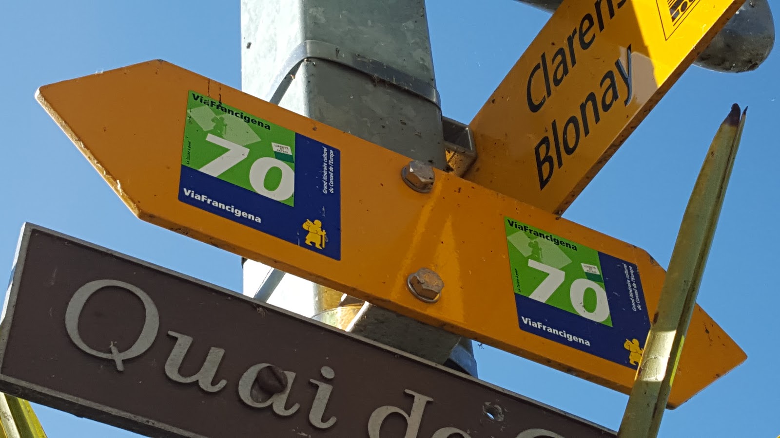
Before long the outskirts of Villeneuve came into sight. Amazingly, this route forms part of the Via Francigena, a 1,100-mile pilgrimage route between Canterbury and Rome. We keep happening across these ancient routes: perhaps it’s some kind of omen?

Route 70: the Via Francigena runs from Canterbury to Rome

Anyway, it was precisely the sort of day that an idyllic lunch would consist of delicious pizza from a wood-fired oven and a glass of chilled white wine. So that’s exactly what we had, and very good it was too. Then we retraced our steps along the shore back to Montreux in time to prepare for the evening’s concert. 

Igor Stravinsky / Firebird

The arts, and music in particular, has played a significant part in Montreux’s recent heritage, the peace and beauty providing inspiration and the chance of creativity since the early part of the 20th Century. Igor Stravinsky lived here for a time, there is an internationally-acclaimed jazz festival held each year, and Queen recorded their seventh album Jazz here in 1978.

Statue of Freddie Mercury

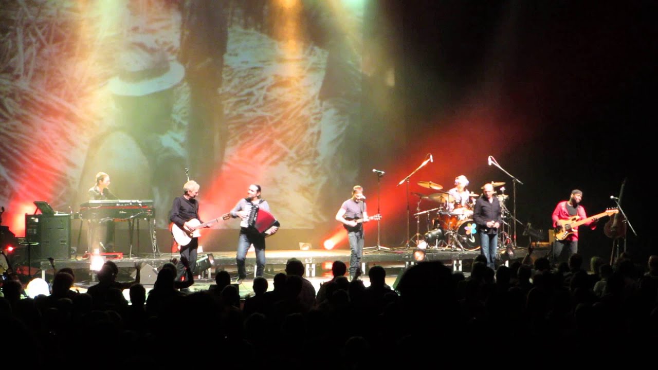
I Muvrini’s brand of Corsican-influenced folk rock might not be to everyone’s taste, but the 2,800-strong audience lapped up every minute of the almost 3-hour performance. The band perform in both the Corsican and French languages, and there is a strong political dimension to the songs. The music employs the unique paghjella polyphonic vocal style which has become synonymous with the Corsican sense of national identity.

I Muvrini

During the evening such subjects as the Paris bombing, Corsican independence and the Environment were touched upon, and the new album Invicta covers the subject of “music for non-violence”. Here is a link to one of their songs:


I speak little French and no Corsican, but such music – emotionally-charged and beautifully played and sung – easily transcends the language barrier, and the impact of the songs and the message within them was not lost on me - or the rest of the crowd. It was a fabulous night, and we left on a high.

“Swiss time was running out”

Sunday morning dawned bright and sunny. After an early breakfast, we were out and about again, looking to make the most of our morning.

Sunday morning lakeshore

Marina at Clarens

First off, we headed along the lake shore in the other direction as far as Clarens, then decided to climb up into the hills behind the town. 

Looking out over Montreux

Following our noses, we ascended through the suburbs and through a couple of villages whose names I forget as we reached the edge of the woods and an enticing number of footpath signs. I do remember we turned round shortly before reaching Glion – our time was running out, and we had a train to catch.

Near Glion


Good walking tantalisingly close

  “I know we’ll never forget”

It was, of course, a memorable weekend. Not only because of the band and the walking we managed to fit in, but for the lovely scenery and ease of access. In fact, we were really surprised how easy it was, how much time we had to play with, and how much walking there was to be done. 

45 minutes from the centre of Montreux and the walking options open up

If you ever wanted a quick weekend getaway, then Montreux makes for an excellent choice. There is much to explore, especially along the lake shore and in the mountains behind the town. It's easy to get to, there is loads of choice when it comes to hotels and food, and the whole trip probably came in at no more than a weekend in London with dinner and a show or an away game in the Champions' League.

We certainly won't forget our time there, and who knows: one day, we may be back!