Friday 28 September 2012

Walking Matters: Zermatt 8th – 19th Sept 2012 – Day 3

Hörnliweg – 9.50 miles / Ascent = 1,039m / Descent = 1,327m

Another promising forecast and the desire to make the most of this fine weather led us to choose this walk to the Hörnlihütte (3,260m) from Schwarzsee. The Hörnlihütte makes for a satisfying objective: perched on the side of the Matterhorn, it’s location alone gives it the feel of a serious mountain day out, let alone the enjoyably gnarly route required to get there. There’s more than a bit of effort required – even though it’s not a particularly long walk taken simply as a there-and-back outing – with enough ascent to provide a challenge given the altitude.

The usual launch pad for tackling the Hörnliweg is Schwarzsee, a small lake at around 2,580m conveniently served by a two-stage gondola ride from Zermatt. We arrived at about 9.30am, and already there were plenty of people about. It’s a popular route, and on days like this it’s best to expect company.


The little lake of Schwarzsee lies just down from the gondola station at the foot of a rocky rib that extends from the Matterhorn. On the far side is the small chapel of St Mary in the Snow – of which more later.


A clear path leads beside the lake and soon begins to zig-zag upwards towards the ridge. There’s a short, flat section where the path crosses a streambed, then it’s upwards again to eventually level out near a small stone cabin (which can just be made out in the photo above).

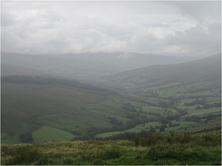
From this promontory the views are extensive: not only back across the valleys and surrounding high mountains but to the base of the Furgggletscher (great word, that: how many more do you know of with three consecutive consonants the same?) as well. The Hörnlihütte is also visible from here, and for those not sure where it is, a sign points right to it.


The next section of the route follows a rising traverse along the side of the ridge. In places, metal walkways have been installed to span the missing path more indistinct sections of the route.


As we continued to rise, we could clearly see below us a path (not shown on our map) heading off towards the Trockener Steg, and we filed this information away for future reference. Before long, a final set of switchbacks led up to a nick in the skyline and we popped out on to the ridge.


From here, the way was clear. A distinct, undulating path follows the ridge – not along the actual crest, but on a safer, less exposed line to one side – and there are new views to appreciate over the Zmuttbach valley to the Dent Blanche (4,357m) and the mountains beyond.

After a fairly simple half-mile or so, we reached the base of the final climb – a series of zig-zags up a narrow fin of rock, weaving back and forth between the crags and eventually gaining the Hörnlihütte after some 300m of vertical gain. It’s not especially difficult, but the north-facing aspects can hold on to any ice and snow around and the sides drop away quite steeply. Think something like Striding Edge on an average 40° gradient, and you’ll get the general idea. It’s not quite as exposed as that, but a slip here would likely test your insurance cover to the full and bring a premature end to your holiday.


In the photo above, the path can be seen zig-zagging up the left hand side of the crag in the foreground, and there are some people there to provide a sense of scale. A side-on view (taken later in the week) shows the ridge and the final climb (marked in red) with the Hörnlihütte shown left of centre.


Last time we did this climb there was quite a bit of ice and snow about, which resulted in some uncomfortable moments. This time we were a bit more prepared: conditions were much clearer this time, but there were still a few slippery patches which we felt more confident about with Yaktrax on – although it must be stressed these are in no way a substitute for crampons should conditions require them.

Also unlike last time the route was pretty busy, and when we reached the hut we found out why: they were open! The top was crowded and full of people eating at the hut, so we drifted to one side to eat our lunch. I didn’t manage to get a photo of the hut, so here’s one from our previous visit in 2006.


The view today was like this.


The Hörnlihütte (3,260m) can be considered in one of two ways: either the last point before reaching the Matterhorn proper, or the first point on it. Either way, this is where many aspiring summiteers begin their adventures. For us, though, this was as close to the Matterhorn as we’ll ever get.

As we ate our lunch we saw a party arrive back down, at least one climber looking very much the worse for wear – badly sunburnt, exhausted and fixed with a thousand yard stare. It just goes to show, even in this day and age with modern equipment, techniques and information, the mountains will always have the last say in whether they let you summit.


The return route was a simple matter of retracing our steps. Shortly before reaching the Schwarzsee, we took a minor path to bring us out by the lake at the chapel of St Mary in the Snow. We popped in for a quick look round and found this picture on the wall.


Legend has it that two Italians were out climbing when bad weather descended. Lost and afraid for their lives, and having exhausted all other options, they prayed for safety - promising to build a chapel in thanks to the Lord if they were helped. Luckily for them, two Zermatt mountaineers happened along to rescue them, and true to their word they built the chapel on the very spot their lives were spared.

As there was a little time left in the day, we decided to get off the gondola at Furi and have a drink before walking back to Zermatt, adding an extra couple of miles. It had been another warm and sunny day, especially at lower levels, and the gentle trundle downhill was a nice way to relax and wind down after our earlier exertions.

Thursday 27 September 2012

Walking Matters: Zermatt 8th – 19th Sept 2012 – Day 2

Meet Me On The Gorner – 12.75 miles / Ascent = 760m / Descent = 2,174m

Another fine, warm day beckoned, so – armed with our newly acquired lift passes – we decided to take the rack railway up to the Gornergrat. Trains run every 24 minutes from opposite the main railway station in Zermatt, and take about 33 minutes to reach the top pausing at a handful of intermediate stops on the way (the Swiss, famous for clocks and watches, are nothing if not meticulous about their timings). It has to be said: there can’t be many more picturesque and impressive journeys by train anywhere in the world.


The top station, at about 3,100m, is not quite what you might expect. Surrounded as it is by a shopping and café complex, the twin silver domes of the Kulm hotel, an Observatory and a small chapel, it has a very different feel to most gondola top stations – definitely more shopping mall than ski chalet.


It’s fairly busy, too, even early in the day, with people milling about taking pictures of the fantastic views – including the ubiquitous, dominant Matterhorn and a multitude of glittering glaciers – and enjoying the tourist thing before catching the train back down again.


The “grat” part of the Gornergrat refers to the narrow ridge that extends eastwards from this complex towards the Hohtälli and a succession of higher summits beyond. A clear path follows the ridge for around half a mile to reach a minor top with a convenient flat rock to sit on, after which things get a bit less distinct.


It doesn’t take long to leave the crowds behind, and here you can get your bearings and take in the spectacular all round views on offer – including over the Gornergletscher to the Monte Rosa massif – in relative peace.


Besides a cluster of mighty summits, there are no fewer than 9 major named glaciers pouring from the icecap: awesome – in the true sense of the word – is the only way to describe it.


Retracing our steps slightly, we picked up a clear path leading down towards the Gornergletscher. Steep and perilous and slippery with loose rock, a fall here is not likely to be lethal (merely painful) but is not recommended. The grassy banks are covered in thousands of tiny alpine plants (at this time of year not at their best, but which in springtime must be glorious) and there are photo opportunities galore. Best to stop first to gawp, though, rather than miss your step.


At a comfortable pace it takes about 1 hour to reach the bottom, where the reward is a more sensibly graded path running alongside the glacier. After a brief rest, we headed left in the direction of the Monte Rosa Hütte.


The hut itself sits on a rocky buttress between two glaciers (centre left of picture above), and requires a glacier crossing to reach it. Although plenty were going for it, we didn’t have the skills or equipment required to take it on, and a crevasse rescue would be so time consuming. So we followed the path as far as we could, and found a rock to sit on – overlooking the confluence of two mighty glaciers – for first lunch.


For anyone remotely interested in Geology (in general) or Glaciation (in particular) this is an awesome place to be. Because of the massive timescales in which most Geological events occur and the devastation usually associated with them when they do, it is rare to be able to see Geology in action. But here you can really get a sense of it happening all around you, even as you sit and watch or walk amongst it. It’s a strange feeling, and hard to verbalise, but one which is at the same time both incredibly wondrous and slightly frightening.


After lunch we returned along the same path, past the junction with the path we came down earlier, and continued on a rising traverse above the Gornergletscher towards the Riffelhorn and the little lake of Riffelsee.


From the Riffelsee, a small lake in which the reflection of the Matterhorn can sometimes be seen, we headed over wet, grassy slopes towards Riffelberg. It was another warm day, but having completed the paths we set out to do in good time, we decided to walk back to Zermatt. We stopped at the Buffet & Bar in Riffelberg for a drink – a bit of a soulless, canteen-y type place but with one major attraction: a large terrace with tables and sun loungers all facing one thing. It’s big, and it begins with M: any ideas?

From Riffelberg we dropped off the plateau down a steep, zig-zag path across grassy hillside towards Riffelalp.


There are several routes down to the valley from here, but we wanted one that took us close to Zermatt. We passed the station (a stop on the Gornergrat line we came through on the way up) and picked up a path dropping through the woods. Now we were below the tree line, the shade provided welcome relief from the intense sun and warm temperatures matching yesterday. It was a very pleasant stroll, and we caught a glimpse of our first Black Squirrel of the holidays.


Crossing the railway line again, we entered the outskirts of Zermatt via the quiet suburb of Winkelmatten and weaved our way through the houses back to the apartment. We were pretty tired and perhaps a touch dehydrated after a long day in the sun, but had enjoyed a great walk and got a few solid miles under our belts as well – including, for the first time this trip, some at altitude.

Dinner (same as yesterday) and a quiet evening ensued.

Wednesday 26 September 2012

Walking Matters: Zermatt 8th –19th Sept 2012 – Day 1

Where’s Wolli? – 9.75 miles / Ascent = 924m / Descent = 898m

There’s often a mild sense of disorientation associated with waking in a strange place for the first time, with a slight jarring experienced during the transition from light sleep to alertness. And this morning was no exception. Ah, yes: that’s where we are, the apartment that is to be our home for the next dozen days. Pulling back the curtain a fraction, I looked out: early morning sunshine was clipping the high peaks at the head of the valley, and the skies were a clear, unblemished pale blue. Our first full day in Zermatt was set to be fine weather.

By way of acclimatisation – both to the conditions and the unexpectedly warm weather – we opted for a fairly easy walk: from town, up and along the valley-side, down to the hamlet of Furi (where the annual Zermatt Shepherd Festival happened to be taking place) and back again.


We took a narrow alley from the centre of town that soon gave way to a switchback path up the hillside. At each junction we took the highest option heading south-west, passing through a tiny collection of houses and barns at Herbrigg to reach Hubel, a climb of about 350m.


As we gained height, views began to open up – firstly, back over Zermatt, then ahead towards the Matterhorn.


There was hardly a cloud in the sky.


In case the term “acclimatisation” appears a little dramatic, here are a few facts. The village of Zermatt sits at the end of the Matter Valley at an altitude of 1,620m. That’s a full 276m higher than the summit of Ben Nevis. From there, the lift and rail system can deliver you to around the 3,000m mark – well above the level at which medics advise us altitude-related health issues such as AMS (or worse) can begin to kick in.

The highest peaks in the area are then a further 1,500m or so higher still, with the high point of the Monte Rosa massif – the Dufourspitze, the second highest summit in the Alps (and Western Europe) – topping out at 4,634m. Of the top twenty highest Alpine peaks, no fewer than fourteen surround this valley.

So, as you can see, altitude does have a bearing in these parts, and the air is definitely thinner here than in the flatlands of the East Midlands where our home stands at a not-so-towering, oxygen-rich, 110m above sea level. And it’s not only about health, it’s also about not wanting to be seen struggling up the hills with all the nip, zip, lightness and speed of an over-laden, badly tuned traction engine.


But back to the walk. We followed a contour path along the valley-side, gently rising to skim the 2,100m contour, with the hamlet of Zmutt sitting in the sunshine below us. The trails were clear and made for fairly easy going, which was helpful given the surprisingly warm morning.


Gradually our bearing swung more towards the west as we worked our way into a side valley beneath the mighty glacier-ridden North Face of the Matterhorn. Here, the power of the Zmuttbach stream had been harnessed by man as part of a Hydro-electric power generation scheme, and dammed to form a small lake.


As it was still quite early, we decided to follow the valley for a little way – partly by way of a recce, and partly to find a nice rock on which to perch for lunch. The view towards the Schönbielhütte and the end of the valley proved enticing, and we would visit this area again in days to come. The constant dodging of waves of MTBers, however, was less welcome, polite as they were.


Retracing our steps, we passed through the confluence of paths that is Zmutt, crossed the river by a high bridge over the narrow gorge, and joined a tarmac road leading down towards Furi. Temperatures were now up into the 25°C+ range, definitely T-shirt weather, but which at altitude and with cooling breezes is definitely a recipe for sunburn – if suitable precautions are ignored.


The tree-lined road offered the first shade we had encountered all day, and with wild Raspberries growing in the roadside verges to provide a tasty, refreshing snack, we enjoyed the short spell of cool. These roads are largely traffic-free, providing easy going for walkers and cyclists.

It was party time in Furi. We stopped for a quick beer then caught up with the festivities. The Shepherd Festival was in full swing, with judging for the best sheep underway as we arrived.


It was also the “birthday” of Wolli, an illustrated character of sheepy heritage and star of several children’s story books, who made an “appearance” at the show – much to the delight of the hundreds of kids in the audience. I must admit it looks kind of scary to me, but the kids seem to love it.


However, it was time to move on. We picked one of the several routes back towards Zermatt, a steady trundle back to town passing through another picturesque hamlet – Zum See – on the way: a very pleasant, if un-taxing, first walk.


Back in Zermatt, we popped into the Co-op for a few supplies before retiring to our balcony to relax and read. For dinner, we rustled up a more-than-adequate Meatballs in Tomato Sauce and Pasta in our little kitchen, before taking a short evening stroll around town.

Monday 3 September 2012

Station To Station – approx 9.75 miles

Sunday August 26th 2012

Map: OS Explorer OL2 – Yorkshire Dales: Southern & Western Areas

Ribblehead Station – Blea Moor Road – Dales Way (N) – Winshaw – Black Rake Road – Newby Head Gate – Pennine Bridleway (N) – Swineley Cowm – Arten Gill Moss – Dent Fell – Coal Road – Dent Station

In complete contrast to yesterday’s circular walk from a guidebook, we decided today on a linear walk from the map. The plan was simple enough: park at Dent Station, the highest main line station in England, catch the train to Ribblehead and walk a route back again. Which is what we did.


Being a Sunday, there were fewer trains to choose from than might be expected on a (Bank Holiday) weekend in the height of the tourist season, but I had printed off a timetable beforehand so knew that the first one of the day was due at 10.40am. At least this gave us chance for a lazy start to the day.


We boarded the train for the nine-minute journey to Ribblehead, the next station along the line. It’s a very nice, scenic ride although £3.10 for a single ticket seems enough to me. However, the train was pretty packed: a useful service, well supported – which is good.

Before long we were stepping on to the platform at Ribblehead, surrounded by the majesty of the 3 Peaks. The first part of the walk took us along the busy B6255. For the most part it was possible to keep to the safety of the grass verge, but the unremitting traffic was an annoyance tempered only by the fantastic views. It was a busy morning round Ribblehead.


At the planning stage, we had devised two possible routes for this walk: following the Dales Way over Blea Moor to meet the Pennine Bridleway at Newby Head and on from there, or via the Pennine Way to Cold Keld Gate, then PBW to Newby Head to join the same finishing section. In the end, we opted for the shorter version: with a later start and Missy G still not 100% fit, we felt the 13+ mile route of the second option might be a bit too much.

From the road, we made the short climb up on to Blea Moor and stopped for a quick snack break. A cloud topped Pen-Y-Ghent sat in the middle distance.


For the next mile or so we followed an undulating path of lovely, wet bogginess. Behind us, the distinctive flat top of Ingleborough dominated the skyline.


Soon, though, we reached the firmer footing of Black Rake Road, and our route ahead over Wold Fell came into clearer view.


On reaching the road above Dent Head viaduct, we turned right to join the PBW on it’s journey north. A little way up the hillside we picked a spot for lunch, another view of Pen-Y-Ghent gracing the middle distance.


Thus far it had been an overcast but dry start to the day. However, as we ate our sandwiches, we could see the rain sweeping in from the west, and knew this was soon about to change.


So we took the opportunity to don our wet-weather gear: with lunch on the inside and waterproofs on the outside, we felt ready to take on whatever the afternoon had to throw at us.

From the brow of the hill, we began the short descent to the junction of paths at the top of Arten Gill. Last time we had been this way, parts of the path were still being upgraded (after all this is now a bridleway, and needs a suitable surface for both horse and cycle riders). That work was now complete, and grass was already growing up through the stones to stabilise the bed.


The views from here were somewhat curtailed by the rain and low cloud, but out there in the clag lay Whernside, Crag Hill, Middleton Fell – and, beyond, the Lake District. It’s funny: as walkers, we often dream of long days of fabulous weather and fantastic views, but sometimes the quiet introspection and inward reflection brought on by paddling for ages through a downpour, raindrops constantly pattering on your waterproofs hood, can be just as rewarding.

Our route continued to follow the PBW on a good track that contoured round the west side of Great Knoutberry Hill. At 672m, this fell falls just a whisker below the exalted top ten highest peaks in the Yorkshire Dales, but it is still a worthy summit. We would be bypassing it today, but the views along Dentdale from its flanks are impressive, even on a poor day such as this!


Finally, we met the Coal Road and pottered downhill towards Dent Station. We passed a foreign tourist pushing her bike uphill in the rain, looking a bit forlorn and wondering how much further she had to go. I have to be honest; she wasn’t getting a very good impression of English summer weather – on days like today, the subtle enjoyments of the great outdoors are more difficult to discern.

Which is a pity really, because – as we’d proved once again – you can still have a great day out if you pack your lunch, your waterproofs and a slice of positive thinking.